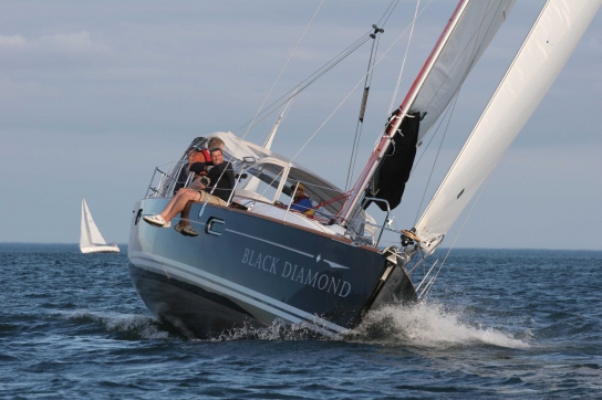
Crossing the Gulf Stream, Rounding Cape Hatteras.
Our Strategy & Track and Use of On Board Electronics.
Sirius Satellite Weather Station
Another great piece of equipment to have on board for ocean work is the Sirius Satellite weather station. You will have live weather reports, alerts, alarms, and graphical live weather anywhere in North America and the Caribbean. NOAA Weather reports for all the regions of the US East coast, daily weather conditions, wind reports and forecasts. Front movements, Storms, Tropical depressions, Hurricanes, Wave heights, Wave directions, currents, wind directions and strengths, live feed for weather sea buoys and much more. Equipment and Installation about $1,000 monthly fee is $30 per month, You’ll need a US address. You can use it seasonally, just cancel after the season is over.
My little rant on weather windows…
Same information available as Chris Parker, except you don’t get his advice or interpretation. Chris Parker knows his stuff, is very knowledgable, My personal experience with Chris Parker has been, he will more often than not tell you to stay put, since he does not want to be responsible for you going out if the weather is not perfect. This is just my feeling, others may have different experiences. If he tells you to go out, you will most likely be fine to go out! The weather is still very unpredictable, and you will have to put on your big boy pants, and make your own decisions. Or be one of those folks that sit in No Name Harbour and do not go anywhere. There are lots of them sitting in Florida waiting for the perfect weather window after taking months to get there down the ICW. Believe it or not, I have heard of people sitting in Florida for over a year waiting for perfect weather. Be prepared and have the right safety equipment, sound boat and capable crew who can help – in case you know what hits the fan!
We have been watching the weather reports all the way down the Hudson, and all the way towards the Cape. The weather looked very good for a fast and safe passage. We knew we had to out run this storm that was coming on Monday, and it was important we left on Friday night as planned. If things changed, or we could not out run it, we would have ducked into the inside of the ICW, and navigated around the cape inside the US coast using the ICW. But things looked good, so we proceeded towards the Cape. Example; Storm coming Monday, Many would wait that storm out, and not leave until the following week, to find much worse conditions the following week.
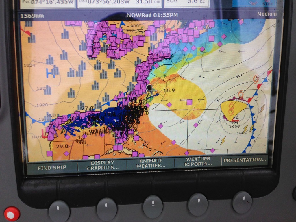
Above is an example of the screen on this actual passage. The pink boxes and triangles are weather stations, you can click on them and get live reports of what is happening right there right now. In the middle of the screen you see our Black Boat, with a cross on it, that is the cursor. We are just about to round Cape Hatteras. The black simple arrows on the water show the wave direction. Further east into the Atlantic, right on top of Bermuda, you will see Hurricane Melissa! You can see the predicted path of the hurricane, so we know it is not a threat, and she is over 1,000 miles away. To the right of her, you will see is a cold front and stationary front and some lighting strikes. You can also see the isobars, and their barometric pressure all over the chart. The closer the lines together the more wind you’ll have.
You can see lightening strikes of our starboard bow. However it is still over 100 miles ahead of us. Just behind us you will see a cold front, marked by a blue line and blue triangles. This cold front passed through Canada, and many of you might remember the strong winds it brought. We rode this front all the way to the Bahamas. We rode its wind for 700 miles amazing. The black and blue concentration closer to land is a rain, wind and lightening storm. We have been watching this move very slowly over the US, and was not a threat if we played our cards right. The speed at which we were travelling, it looked like there would be no problem in us passing in front of it and it would ride past our stern. In fact this is what ended up happening. We hardly even got wet!
Gulf Stream shown in above screen.
Above you will see water temperatures. The red colouring is very warm or lets call it hot water. Originating from the Gulf, it flows around Florida, and up the US coast. It can flow easily at 5 knots northwards. Over the Cape you can see Blue and Light Blue water temperatures. This is cold water. Then in the middle where it mixes you will see yellow, warm water. The Gulf Stream flows northward until it hits the land which funnels it out into the Atlantic. This land is called Cape Hatteras. This is the most dangerous cape in North America. Water is shallow off this cape, only 50 feet in some places. When you have a northerly blowing against the stream, you will get very high waves building in shallow waters. You don’t want to hug this coast, either go offshore, or go on the inside. It is suggested not to ride against the stream in anything over 10 knots. Below we will go into more detail exactly how we did it.
Due to what we were seeing on this screen it was time to make preparations for a nice ride! We were expecting 20-30 knots of wind, and some high seas. We put a double reef in the rig and off we were. When sailing in the ocean, boat and rig preservation is key! Many people push their boats too hard, and end up breaking them. Breaking the rig can be catastrophic anywhere especially offshore. At the very least, you won’t get to your destination fast without a rig. Many long distance ocean races are lost simply by pushing the boat and breaking the rig. Why would you spend years preparing for an offshore passage, and then break the boat, cause you want to get there a little faster? Much wiser to reef early, and reef aggressively. Less strain on the rig, more comfortable ride, less heel. Excessive heel combined with large waves, and then throw in a rouge wave to grab your keel. The next thing you know your being rolled. More on rouge waves in the next post!
SPOT CONNECT Messenger. – “Prep for 20-30 knots of wind”
http://www.findmespot.com/mylocation/?id=EeGsT/36.58064N/74.81583W
SPOT CONNECT Messenger. – “Baked 2 loafs & Put a reef in, high winds coming!”
http://www.findmespot.com/mylocation/?id=EeZv-/35.87080N/74.83667W
Crossing the Gulf Stream
For more details on proper routing to Florida or the Bahamas from Northern destinations check out this link also:
SPOT CONNECT Messenger. – “Crossing the Gulf Stream!”
http://www.findmespot.com/mylocation/?id=Eemu1/35.29741N/74.26111W
Rounding the Cape
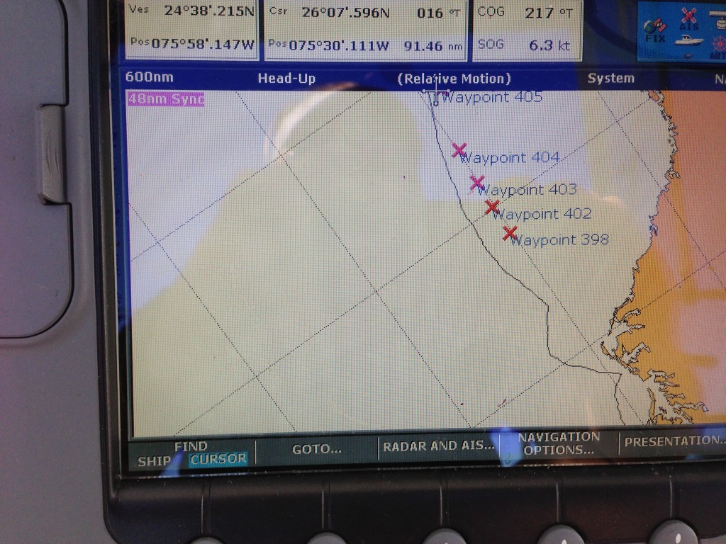
Above you are looking at a heads up view, meaning which way the boat is moving, we are moving south, so the top of the screen is south the bottom is north, and to the right is west. The white is the ocean and you can see the land on the right of the screen. That land out furthest is Cape Hatteras. You can see our track sailed. The “X”s are marked points where we plotted our buddy boat, Fortune’s Favour. Every few hours we would call each other, and plot our last location. Due to the wind conditions, we deliberately sailed close to the cape on the northern side, there is no danger in this, the danger is on the other side as the Gulf stream flows up that way. We did this, so our next tack will take us on track that will see us strategically rounding the cape perpendicular to the Gulf stream. If you look at the previous screen, you will see the Gulf Stream flowing out into the ocean. We want to cross this perpendicularly and keep this course for about 100 nautical miles. Once we were mostly clear of the stream we tacked back as you can see. Then the storm passed behind us, and the wind shifted, so we tacked again, and got a nice lift to the Bahamas and rode the cold front all the way down!
When you are out here, you can’t be afraid of being offshore. On this trip off the coast of Florida we were some 300 nautical miles or 500 kms offshore. Staying close to shore is not necessarily safer, especially in a bad storm. You need to sail the weather. You need to stay out of the stream especially if a northerly is blowing. In any case why do you want to sail against a stream. if you stay just outside of it, you may get a back current that actually gives you a push. But it is too hard to nail those, best to stay clear in a northerly or an approaching storm.
You might be able to orient yourself a little easier with this view. But you see the track is the same. Out far offshore around the cape, and then set a course for your destination. In our case the Bahamas!
If you were headed to the US or British Virgins, you would head further offshore and line yourself up with you destination and start heading south. This is very generally speaking. You can look that up yourself, this is a blog on the Bahamas!
Track from our SPOT.
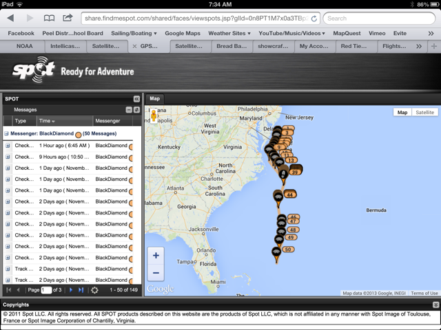
Once we rounded happily, we set a way point for San Salvador Island in the Bahamas, one of the best land falls approaching from the north. According to the World Cruising Routes which illustrates the prevailing winds and currents at different times of the year, this is the recommended route and the best time of year to do it. Now riding the cold front, we were consistently hitting over 10 knots of Speed over ground, and on our way, about 1/2 way there!
SPOT CONNECT Messenger. – “We’ll on our way, surfing 15′ seas and hitting 11 knots”
http://www.findmespot.com/mylocation/?id=EfdTq/32.63791N/74.38803W
SPOT CONNECT Messenger. – “1/2 way there from NY and 1/4 from the Cape”
http://www.findmespot.com/mylocation/?id=EfeBq/32.59534N/74.36908W